Toubkal here we come
http://nl.youtube.com/watch?v=Qe2JFMTILCY&feature=related
Saturday, April 26, 2008
Saturday, April 12, 2008
Mt Ranier Info
Climbing is good on Mt Ranier. To keep up with conditions and to get info refer to Mike Gauthier's Blog http://www.mountrainierclimbing.blogspot.com/.
Tuesday, March 11, 2008
Where is the trailhead? Lesson from Mt Shasta
Sometimes I get impatient. I just wanted to get on the mountain, ascend alpine style and get back home before work. Even on a popular mountain, it can be hard to get to the trailhead. For example, the last time I went to Mount Shasta, I found the gate closed. Shoot, I didn't even know there was a gate. It was after dark. My intent was to do an alpine start. Instead I went back home. I wasn't prepared to change my plans. Time is of the essence when you are a working girl. I called the Mt Shasta Ranger station. They told me of an alternate route, where to park and I made topos to bring with me the next time. Mount Shasta is in my backyard and teaches me many lessons. If I had gone somewhere farther from home, I wouldn't have gone home. I would have been on an adventure.
Friday, March 7, 2008
Map Cabane de Bertol

Se rendre à Arolla et se garer sur le parking à l'entrée du village.Continuer sur une route goudronnée en direction de la central hydro-électrique.Suivre les indications pour la cabane de Bertol.On emprunte un petit sentier en direction du plan de Bertol.La cabane est visible sur son éperon rocheux. Continuer dans cette direction

Saturday, March 1, 2008
Where in the world is the Cabane de Bertol?
The dream started with a postcard, one that I bought while on vacation. It pictured a hut, located high on the mountain. How could that be? This dream has turned into unfinished business. I want to climb to that cabane and then summit the mountain.
Wednesday, February 20, 2008
Leaving Mt Shasta
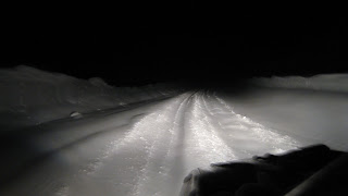 When leaving Mt Shasta and the road looks like this, you may find the gate closed.
Part 2: Trip to Pico de Orizaba
The proposed itinerary works but check the updated info
1. There are 2 bus stations in the Mexico City airport, go to the old one
2. The bus to Puebla is modern with movies, the bus to Tlachichuca stops at many small towns. Plan 3 hours for each.
3. It is also a 3 hour, 4 wheel drive to basecamp.
4. The roof is collapsed on the second smaller hut at basecamp.
5. The weather report for Orizaba, the city, doesn't pertain to the mountain.
Do you have anything to add?
Sunday, February 17, 2008
What do you do when you don't feel like part of the team?
When you go on a guided trip, do you know what to expect? Do you really know what you are getting into? Do you plan to learn to climb on the trip? Are the guides suppose to provide instruction? Early in the trip, if you don't have your guides confidence or you haven't become his/her buddy, will you get enough support to summit? You may feel you are contributing to the team. What do you do when you realize you aren't part of the team?
http://www.myeverest.com/comparing-guides-logistics-climbing-mount-Everest-nepal-img-asian-trekking
http://www1.freewebs.com/mymounteverestexperience/
http://www.myeverest.com/comparing-guides-logistics-climbing-mount-Everest-nepal-img-asian-trekking
http://www1.freewebs.com/mymounteverestexperience/
Saturday, February 16, 2008
Who will be the first woman to do all 14 8000 meter peaks?
Are there any American women in the running?
http://mounteverest.net/news.php?news=17021
http://mounteverest.net/news.php?news=17021
Check out Mt Shasta
Do you have a useful webcam you would like to share?
http://www.snowcrest.net/camera/
http://www.snowcrest.net/camera/
Friday, February 15, 2008
Who is supplying your oxygen tank?
Climbers are often encouraged to use oxygen on summit day? If your team is being supplied oxygen by Henry Todd, it may be riskier to plan on using it?
http://www.mounteverest.net/news.php?id=1733
http://www.mounteverest.net/news.php?id=1733
Thursday, February 14, 2008
Does Your Mountain Guide Have a Hidden Agenda?
Have you ever been rushed up the mountain by your guide? This is an interesting story.
http://www.mounteverest.net/news.php?news=16230
http://www.mounteverest.net/news.php?news=16230
Wednesday, February 13, 2008
Pico de Orizaba Solo
Nothing is more fun than setting out on a trip you have planned. By planned, I mean you have arranged all the logistics. This is a real adventure. Excited by this task, I began to plan my climb to Pico de Orizaba via the Glaciar de Jamapa / Northern Route.
To come up with this preliminary itinerary, I talked to people, went to http://www.summitpost.org/, looked at internet trip reports and read RJ Secore's book. There are details of the trail in Mexico's Volcanos by RJ Secor. This book can be bought in many places. http://www.chesslerbooks.com/eCart/viewItem.asp?idProduct=877
A lot of this info may not be current but it is a place to start. This adds to the adventure.
Itinerary
Getting to the mt:
To avoid gear theft, take only what you need. Plan to carry it in your backpack.
Alaska Airlines has direct flights to Mexico City, Mexico.
Get pesos before leaving the airport, their are no ATMs near the mt
Arrive early so I could get to Tlachichuca before dark
In the airport, at Mexico City, the Estrella Roja bus line goes to Puebla
Keep an eye on your pack,Keep outside pockets locked or empty.
At Puebla, next to the Estrella line take the AU bus at Valles (#8 or # 9) to Tlachichuca
There, find the Reyes Compound(near the Pemex building)
Here you can get dinner, sleep, clean up and breakfast
You can get water and fuel here as well.
About noon, the next day,Sr Reyes can drive you to Piedra Grande(basecamp)
You can also walk to basecamp and depending on the weather, you may have too.
Basecamp is at 4250m or 13,943 feet
At basecamp, there is a stone hut which sleeps 60 on shelves
There is a smaller wooden hut which sleeps 4-12
or as I will, you can tent it.
Going up the mountain can take 1 day or a week.
Everyone has their own style and their own acclimatization schedule.
Some climbers go alpine style, some climb high, sleep low.
Day 1 on the mountain:
Find the start of the trail marked by the large iron cross near the smaller hut.
Scout out the trail as high as possible in the daylight.
Day2 on the mountain:
Go up and camp at 16,000 feet
Day3 on the mt:
Summit, you can descend all the way to the Reyes Compound if you want.
Use these suggestions at your own risk
Saturday, February 2, 2008

Winter Whiteout on Mt Shasta
After checking out the weather report on the http://www.noaa.gov/ site, we decided to take advantage of a weather window on Mt Shasta. The Casaval Ridge was calling. I got my annual climbing pass from the Mt Shasta Ranger station and headed for the traihead.The road was plowed to the Bunny Flats trailhead. Bunny Flats is at 6900ft. Sometimes the gates are closed at 4700ft. This means you would have to cut 4 miles across foot of the mountain to Horse Camp. In this case, you enter the snowy foothills about 150ft before the gate which is just after the Twin Bridges enterance. You can check with the friendly Mt Shasta rangers before entering the wilderness. We acclimated and checked our gear at the trailhead. Due to high winds, we dug a pit to pitch our tent in. The map showed Horse Camp was directly North. Our compass took us straight for the ridge. Using computer Topo maps, we had placed GPS markings on the map to show the route. This was a double check for our compass readings. It proved helpful as we came off the mountain in a whiteout. Shel
Subscribe to:
Posts (Atom)
